
Thank you for supporting this site ❤️
Make a donation
Make a donation
Dar es Salaam topographic map
Click on the map to display elevation.
Thank you for supporting this site ❤️
Make a donation
Make a donation
About this map
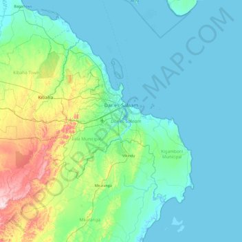
Name: Dar es Salaam topographic map, elevation, terrain.
Location: Dar es Salaam, Coastal Zone, Tanzania (-7.18684 39.00703 -6.56620 39.92805)
Average elevation: 57 m
Minimum elevation: 0 m
Maximum elevation: 387 m
Thank you for supporting this site ❤️
Make a donation
Make a donation
Other topographic maps
Click on a map to view its topography, its elevation and its terrain.
Mwanza
Mwanza features a tropical savanna climate under the Köppen climate classification. Temperatures are relatively consistent throughout the course of the year, tempered by the city's altitude. Thus, the climate is not quite as hot as one might expect, given the city's location near the equator. Average…
Average elevation: 1,178 m
Thank you for supporting this site ❤️
Make a donation
Make a donation
Thank you for supporting this site ❤️
Make a donation
Make a donation