
Thank you for supporting this site ❤️
Make a donation
Make a donation
Loßbruch topographic map
Click on the map to display elevation.
Thank you for supporting this site ❤️
Make a donation
Make a donation
About this map
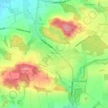
Name: Loßbruch topographic map, elevation, terrain.
Location: Loßbruch, Detmold, Kreis Lippe, Nordrhein-Westfalen, Deutschland (51.97637 8.87766 51.98717 8.91079)
Average elevation: 192 m
Minimum elevation: 136 m
Maximum elevation: 255 m
Thank you for supporting this site ❤️
Make a donation
Make a donation
Other topographic maps
Click on a map to view its topography, its elevation and its terrain.
Thank you for supporting this site ❤️
Make a donation
Make a donation
Stemberg
Deutschland > Nordrhein-Westfalen > Kreis Lippe > Detmold > Berlebeck
Average elevation: 266 m
Lippischer Meierhof
Deutschland > Nordrhein-Westfalen > Kreis Lippe > Detmold
Average elevation: 179 m
Thank you for supporting this site ❤️
Make a donation
Make a donation