
Mälarsee topographic map
Interactive map
Click on the map to display elevation.
About this map
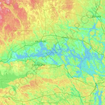
Name: Mälarsee topographic map, elevation, terrain.
Average elevation: 42 m
Minimum elevation: -3 m
Maximum elevation: 224 m
Other topographic maps
Click on a map to view its topography, its elevation and its terrain.
Katrineholm
Schweden > Provinz Södermanland > Katrineholm
Katrineholm, Katrineholms kommun, Provinz Södermanland, Landesteil Svealand, 641 30, Schweden
Average elevation: 48 m