Geolocate

Corrigan topographic map

Click on the map to display elevation.

About this map

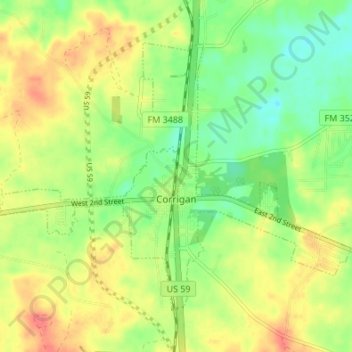
Name: Corrigan topographic map, elevation, terrain.

Location: Corrigan, Polk County, Texas, 75939, United States (30.97862 -94.86125 31.02266 -94.79353)

Average elevation: 76 m

Minimum elevation: 50 m

Maximum elevation: 103 m

Other topographic maps

Click on a map to view its topography, its elevation and its terrain.

Moscow

United States > Texas > Polk County

Average elevation: 98 m

Pluck

United States > Texas > Polk County

Average elevation: 61 m

Segno

United States > Texas > Polk County

Average elevation: 60 m

Schwab City

United States > Texas > Polk County

Average elevation: 66 m

Tobacco Patch

United States > Texas > Polk County

Average elevation: 43 m

Israel

United States > Texas > Polk County

Average elevation: 87 m