
Thank you for supporting this site ❤️
Make a donation
Make a donation
Plum Island topographic map
Click on the map to display elevation.
Thank you for supporting this site ❤️
Make a donation
Make a donation
Plum Island
Maximum dune elevation is about 50 feet (15 m). In the deeper depressions and more sheltered regions between or next to the higher dunes are vernal pools in which black oak, red maple and black cherry can be found. In the underbrush are cranberry. The ferns, moss and leaf cover there shelter salamanders and spadefoot toads.
Thank you for supporting this site ❤️
Make a donation
Make a donation
About this map
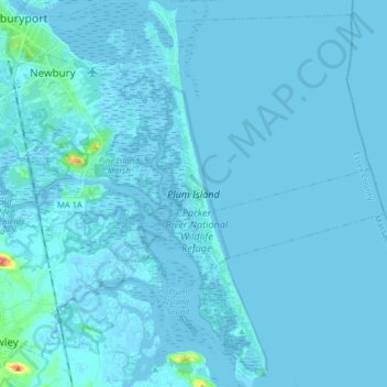
Name: Plum Island topographic map, elevation, terrain.
Average elevation: 2 m
Minimum elevation: -3 m
Maximum elevation: 62 m
Thank you for supporting this site ❤️
Make a donation
Make a donation