
Thank you for supporting this site ❤️
Make a donation
Make a donation
Zheleznogorsk topographic map
Click on the map to display elevation.
Thank you for supporting this site ❤️
Make a donation
Make a donation
About this map
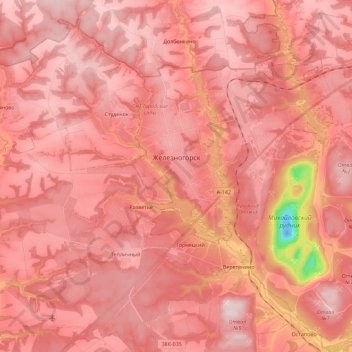
Name: Zheleznogorsk topographic map, elevation, terrain.
Location: Zheleznogorsk, Kursk Oblast, Central Federal District, Russia (52.26198 35.32146 52.40084 35.54386)
Average elevation: 214 m
Minimum elevation: -21 m
Maximum elevation: 275 m
Thank you for supporting this site ❤️
Make a donation
Make a donation
Other topographic maps
Click on a map to view its topography, its elevation and its terrain.
Thank you for supporting this site ❤️
Make a donation
Make a donation
Kursk Oblast
The oblast, with an average elevation is 177–225 meters (580–738 ft), occupies the southern slopes of the middle-Russian plateau. The surface is hilly and intersected by ravines. The central part of Kursk oblast is more elevated than the Seym Valley to the west. The Timsko-Shchigrinsky ridge contains the…
Average elevation: 173 m
Thank you for supporting this site ❤️
Make a donation
Make a donation
Thank you for supporting this site ❤️
Make a donation
Make a donation
Thank you for supporting this site ❤️
Make a donation
Make a donation
Thank you for supporting this site ❤️
Make a donation
Make a donation
Thank you for supporting this site ❤️
Make a donation
Make a donation
Thank you for supporting this site ❤️
Make a donation
Make a donation
Thank you for supporting this site ❤️
Make a donation
Make a donation
Thank you for supporting this site ❤️
Make a donation
Make a donation