
Thank you for supporting this site ❤️
Make a donation
Make a donation
Nula-Tula topographic map
Click on the map to display elevation.
Thank you for supporting this site ❤️
Make a donation
Make a donation
About this map
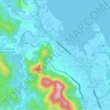
Name: Nula-Tula topographic map, elevation, terrain.
Location: Nula-Tula, Tacloban, Eastern Visayas, 6500, Philippines (11.22929 124.95224 11.26929 124.99224)
Average elevation: 38 m
Minimum elevation: -1 m
Maximum elevation: 282 m
Thank you for supporting this site ❤️
Make a donation
Make a donation
Other topographic maps
Click on a map to view its topography, its elevation and its terrain.