
Thank you for supporting this site ❤️
Make a donation
Make a donation
Khao Kho topographic map
Click on the map to display elevation.
Thank you for supporting this site ❤️
Make a donation
Make a donation
About this map
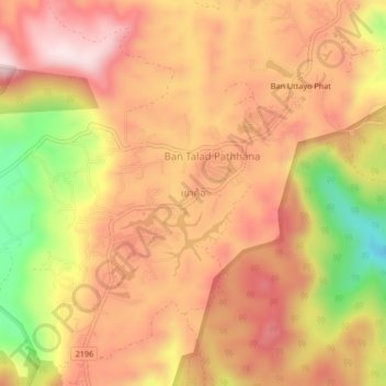
Name: Khao Kho topographic map, elevation, terrain.
Location: Khao Kho, Phetchabun Province, 67270, Thailand (16.62311 100.98621 16.66311 101.02621)
Average elevation: 889 m
Minimum elevation: 616 m
Maximum elevation: 1,052 m
Thank you for supporting this site ❤️
Make a donation
Make a donation
Other topographic maps
Click on a map to view its topography, its elevation and its terrain.