
Thank you for supporting this site ❤️
Make a donation
Make a donation
Leversbach topographic map
Click on the map to display elevation.
Thank you for supporting this site ❤️
Make a donation
Make a donation
About this map
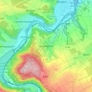
Name: Leversbach topographic map, elevation, terrain.
Average elevation: 233 m
Minimum elevation: 144 m
Maximum elevation: 383 m
Thank you for supporting this site ❤️
Make a donation
Make a donation
Other topographic maps
Click on a map to view its topography, its elevation and its terrain.
Drover Heide
Deutschland > Nordrhein-Westfalen > Kreis Düren > Kreuzau > Stockheim
Average elevation: 184 m