
Seljalandsfoss topographic map
Interactive map
Click on the map to display elevation.
About this map
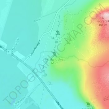
Name: Seljalandsfoss topographic map, elevation, terrain.
Location: Seljalandsfoss, Rangárþing eystra, Southern Region, Iceland (63.61541 -19.98822 63.61551 -19.98812)
Average elevation: 88 m
Minimum elevation: -3 m
Maximum elevation: 370 m
Other topographic maps
Click on a map to view its topography, its elevation and its terrain.
Skogafoss
Skogafoss, Rangárþing eystra, Southern Region, Iceland
Average elevation: 145 m