
Thank you for supporting this site ❤️
Make a donation
Make a donation
Selorio topographic map
Click on the map to display elevation.
Thank you for supporting this site ❤️
Make a donation
Make a donation
About this map
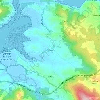
Name: Selorio topographic map, elevation, terrain.
Location: Selorio, Villaviciosa, Asturias, 33317, España (43.49363 -5.38913 43.53363 -5.34913)
Average elevation: 65 m
Minimum elevation: -11 m
Maximum elevation: 304 m
Thank you for supporting this site ❤️
Make a donation
Make a donation