
Thank you for supporting this site ❤️
Make a donation
Make a donation
Buisson topographic map
Click on the map to display elevation.
Thank you for supporting this site ❤️
Make a donation
Make a donation
About this map
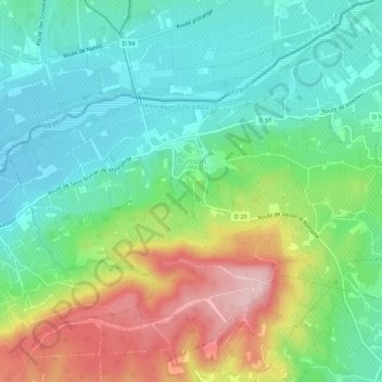
Name: Buisson topographic map, elevation, terrain.
Average elevation: 234 m
Minimum elevation: 153 m
Maximum elevation: 394 m
Thank you for supporting this site ❤️
Make a donation
Make a donation
Other topographic maps
Click on a map to view its topography, its elevation and its terrain.
Les Alazards
Frankrijk > Provence-Alpes-Côte d'Azur > Vaucluse > Beaumont-du-Ventoux
Average elevation: 749 m
Thank you for supporting this site ❤️
Make a donation
Make a donation
Thank you for supporting this site ❤️
Make a donation
Make a donation
Les Lombards
Frankrijk > Provence-Alpes-Côte d'Azur > Vaucluse > Gargas > Les Lombards
Average elevation: 277 m