
Thank you for supporting this site ❤️
Make a donation
Make a donation
Marys Peak topographic map
Click on the map to display elevation.
Thank you for supporting this site ❤️
Make a donation
Make a donation
About this map
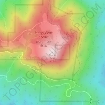
Name: Marys Peak topographic map, elevation, terrain.
Location: Marys Peak, Benton County, Oregon, United States (44.50432 -123.55267 44.50442 -123.55257)
Average elevation: 874 m
Minimum elevation: 576 m
Maximum elevation: 1,245 m
Thank you for supporting this site ❤️
Make a donation
Make a donation
Other topographic maps
Click on a map to view its topography, its elevation and its terrain.