
Pinellas County topographic map
Click on the map to display elevation.
Pinellas County
Elevation in the county ranges from mean sea level to its highest natural point of 110 feet (34 m) near the intersection of SR 580 and Countryside Blvd. in Clearwater. Due to its small size and high population, by the early 21st century Pinellas County has been mostly built out, with very little developable land left available. The county has maintained a fairly large system of parks and preserves that provide residents and visitors retreat from the city and a glimpse of the peninsula's original state.
About this map
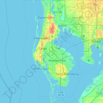
Name: Pinellas County topographic map, elevation, terrain.
Location: Pinellas County, Florida, United States (27.61027 -82.90891 28.17335 -82.54062)
Average elevation: 4 m
Minimum elevation: -2 m
Maximum elevation: 35 m
Other topographic maps
Click on a map to view its topography, its elevation and its terrain.
Wesley Chapel
United States > Florida > Pasco County
According to the United States Census Bureau, the CDP has a total area of 6.1 square miles (16 km2), of which 6.1 square miles (16 km2) is land and 0.04 square miles (0.10 km2) (0.49%) is water. The elevation is about 100 feet (30 m), combined with an inland location, creates more temperature variation in the…
Average elevation: 19 m