
Thank you for supporting this site ❤️
Make a donation
Make a donation
Bayonet Point topographic map
Click on the map to display elevation.
Thank you for supporting this site ❤️
Make a donation
Make a donation
About this map
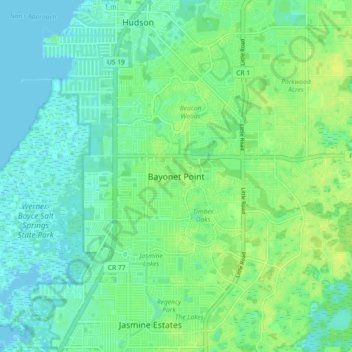
Name: Bayonet Point topographic map, elevation, terrain.
Location: Bayonet Point, Pasco County, Florida, 34668, United States (28.28667 -82.72343 28.36667 -82.64343)
Average elevation: 7 m
Minimum elevation: -2 m
Maximum elevation: 16 m
Thank you for supporting this site ❤️
Make a donation
Make a donation
Other topographic maps
Click on a map to view its topography, its elevation and its terrain.