
Thank you for supporting this site ❤️
Make a donation
Make a donation
Rhigos topographic map
Click on the map to display elevation.
Thank you for supporting this site ❤️
Make a donation
Make a donation
About this map
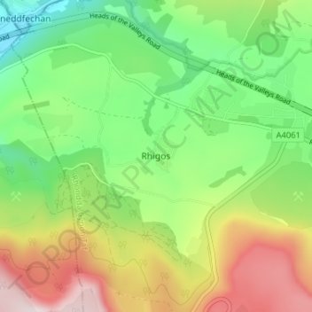
Name: Rhigos topographic map, elevation, terrain.
Location: Rhigos, Rhondda Cynon Taf, Wales, CF44 9QJ, United Kingdom (51.71902 -3.58364 51.75902 -3.54364)
Average elevation: 274 m
Minimum elevation: 71 m
Maximum elevation: 582 m
Thank you for supporting this site ❤️
Make a donation
Make a donation
Other topographic maps
Click on a map to view its topography, its elevation and its terrain.
Thank you for supporting this site ❤️
Make a donation
Make a donation
Thank you for supporting this site ❤️
Make a donation
Make a donation