
Thank you for supporting this site ❤️
Make a donation
Make a donation
Catamount Mountain topographic map
Click on the map to display elevation.
Thank you for supporting this site ❤️
Make a donation
Make a donation
About this map
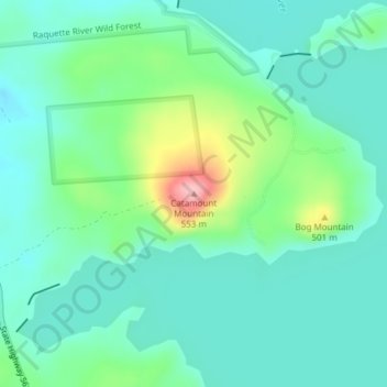
Name: Catamount Mountain topographic map, elevation, terrain.
Average elevation: 433 m
Minimum elevation: 396 m
Maximum elevation: 550 m
Thank you for supporting this site ❤️
Make a donation
Make a donation
Other topographic maps
Click on a map to view its topography, its elevation and its terrain.
Higley Flow State Park
United States > New York > Saint Lawrence County > Town of Colton
Average elevation: 296 m