
Thank you for supporting this site ❤️
Make a donation
Make a donation
Cañete topographic map
Click on the map to display elevation.
Thank you for supporting this site ❤️
Make a donation
Make a donation
About this map
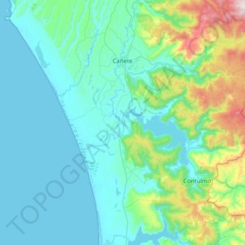
Name: Cañete topographic map, elevation, terrain.
Location: Cañete, Provincia de Arauco, Biobio Region, Chile (-38.13033 -73.54544 -37.69198 -73.01543)
Average elevation: 191 m
Minimum elevation: 0 m
Maximum elevation: 1,346 m
Thank you for supporting this site ❤️
Make a donation
Make a donation