
Make a donation
Stony Rapids topographic map
Click on the map to display elevation.
Make a donation
About this map
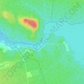
Name: Stony Rapids topographic map, elevation, terrain.
Average elevation: 227 m
Minimum elevation: 209 m
Maximum elevation: 272 m
Make a donation
Other topographic maps
Click on a map to view its topography, its elevation and its terrain.
Morin Lake
Canada > Saskatchewan > Northern Saskatchewan Administration District > Morin Lake
Average elevation: 385 m
La Loche
Canada > Saskatchewan > Northern Saskatchewan Administration District > La Loche
Average elevation: 447 m
Black Lake
Canada > Saskatchewan > Northern Saskatchewan Administration District > Black Lake
Average elevation: 293 m
Air Ronge
Canada > Saskatchewan > Northern Saskatchewan Administration District > Air Ronge
Average elevation: 369 m
Make a donation
Garson Lake
Canada > Saskatchewan > Northern Saskatchewan Administration District > Garson Lake
Average elevation: 470 m
Hall Lake
Canada > Saskatchewan > Northern Saskatchewan Administration District > Hall Lake
Average elevation: 391 m
Doré Lake
Canada > Saskatchewan > Northern Saskatchewan Administration District
Average elevation: 475 m