
Thank you for supporting this site ❤️
Make a donation
Make a donation
Zemst topographic map
Click on the map to display elevation.
Thank you for supporting this site ❤️
Make a donation
Make a donation
Zemst
Middeleeuwse sluistoren op de Zenne ter hoogte van Weerde
Thank you for supporting this site ❤️
Make a donation
Make a donation
About this map
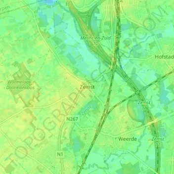
Name: Zemst topographic map, elevation, terrain.
Location: Zemst, Halle-Vilvoorde, Vlaams-Brabant, Vlaanderen, 1980, België (50.96422 4.44508 51.00422 4.48508)
Average elevation: 9 m
Minimum elevation: -1 m
Maximum elevation: 14 m
Thank you for supporting this site ❤️
Make a donation
Make a donation