
Thank you for supporting this site ❤️
Make a donation
Make a donation
Poage Lake topographic map
Click on the map to display elevation.
Thank you for supporting this site ❤️
Make a donation
Make a donation
About this map
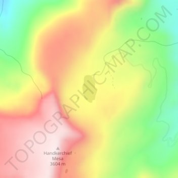
Name: Poage Lake topographic map, elevation, terrain.
Location: Poage Lake, Rio Grande County, Colorado, United States (37.49747 -106.64449 37.50166 -106.64166)
Average elevation: 3,369 m
Minimum elevation: 3,094 m
Maximum elevation: 3,607 m
Thank you for supporting this site ❤️
Make a donation
Make a donation
Other topographic maps
Click on a map to view its topography, its elevation and its terrain.
Del Norte
United States > Colorado > Rio Grande County
Relatively-speaking, it is located where the Rio Grande leaves the San Juan Mountains and enters the San Luis Valley, near its confluences with Pinos Creek and San Francisco Creek, respectively. Due to its location on the western edge of the valley, a variety of climates, vegetation regions, and ecosystems…
Average elevation: 2,416 m
Thank you for supporting this site ❤️
Make a donation
Make a donation