
Make a donation
North Wilna topographic map
Click on the map to display elevation.
Make a donation
About this map
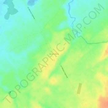
Name: North Wilna topographic map, elevation, terrain.
Average elevation: 203 m
Minimum elevation: 186 m
Maximum elevation: 225 m
Make a donation
Other topographic maps
Click on a map to view its topography, its elevation and its terrain.
City of Watertown
United States > New York > Jefferson County
Watertown is around 60 miles (97 kilometers) northwest of Syracuse, 20 miles (32 kilometers) south of the Thousand Islands and 328 miles (530 kilometers) northwest of New York City. According to the United States Census Bureau, the city has a total area of 9.3 square miles (24 km2), of which 9.0 square miles…
Average elevation: 150 m
Make a donation
Make a donation
Make a donation
City of Watertown
United States > New York > Jefferson County
Watertown is around 60 miles (97 kilometers) northwest of Syracuse, 20 miles (32 kilometers) south of the Thousand Islands and 328 miles (530 kilometers) northwest of New York City. According to the United States Census Bureau, the city has a total area of 9.3 square miles (24 km2), of which 9.0 square miles…
Average elevation: 150 m
Make a donation
Just Room Enough Island
United States > New York > Jefferson County > Village of Alexandria Bay > Alexandria Bay
Average elevation: 78 m
Village of Cape Vincent
United States > New York > Jefferson County > Town of Cape Vincent
Average elevation: 84 m
Make a donation
Village of Theresa
United States > New York > Jefferson County > Town of Theresa
Average elevation: 121 m