
Thank you for supporting this site ❤️
Make a donation
Make a donation
Bork topographic map
Click on the map to display elevation.
Thank you for supporting this site ❤️
Make a donation
Make a donation
About this map
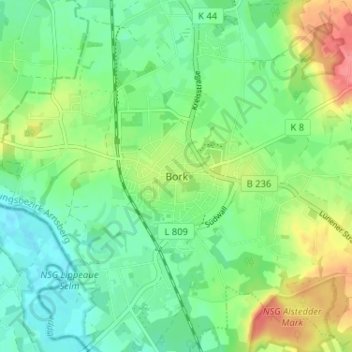
Name: Bork topographic map, elevation, terrain.
Location: Bork, Selm, Kreis Unna, Nordrhein-Westfalen, 59379, Deutschland (51.64514 7.44723 51.68514 7.48723)
Average elevation: 66 m
Minimum elevation: 43 m
Maximum elevation: 108 m
Thank you for supporting this site ❤️
Make a donation
Make a donation
Other topographic maps
Click on a map to view its topography, its elevation and its terrain.