Geolocate

Osceola County topographic map

Interactive map

Click on the map to display elevation.

About this map

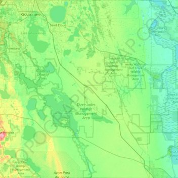
Name: Osceola County topographic map, elevation, terrain.

Location: Osceola County, Florida, USA (27.64199 -81.65709 28.34852 -80.86242)

Average elevation: 19 m

Minimum elevation: 0 m

Maximum elevation: 91 m

Other topographic maps

Click on a map to view its topography, its elevation and its terrain.

Hillsborough County

USA > Florida

Average elevation: 20 m

Lee County

USA > Florida

Average elevation: 5 m

Middle River

USA > Florida > Fort Lauderdale

Average elevation: 6 m

Dawson Island

USA > Florida > Jacksonville

Average elevation: 2 m

St. Augustine

USA > Florida > St. Augustine

Average elevation: 5 m

Duval County

USA > Florida

Average elevation: 11 m

Tallahassee

USA > Florida > Tallahassee

Average elevation: 36 m

Pembroke Pines

USA > Florida > Pembroke Pines

Average elevation: 5 m