
Liplje topographic map
Interactive map
Click on the map to display elevation.
About this map
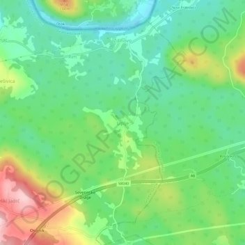
Name: Liplje topographic map, elevation, terrain.
Average elevation: 235 m
Minimum elevation: 160 m
Maximum elevation: 378 m
Other topographic maps
Click on a map to view its topography, its elevation and its terrain.
Grad Rijeka
Croatia > Primorje-Gorski Kotar County
Since records began in 1948, the highest temperature recorded at the local weather station at an elevation of 120 metres (390 ft) was 40.0 °C (104.0 °F), on 19 July 2007. The coldest temperature was −12.8 °C (9.0 °F), on 10 February 1956.
Average elevation: 209 m
Krk
Croatia > Primorje-Gorski Kotar County
A Eurasian griffon vulture colony lives in protected in an area called Kuntrep on Krk., There they breed at low elevations, with some nests at 10 m (33 ft). Therefore, contact with people is common.
Average elevation: 95 m
Lošinj
Croatia > Primorje-Gorski Kotar County > Veli Lošinj
Lošinj is part of the Cres-Lošinj archipelago. The Cres-Lošinj archipelago includes the two major islands Cres and Lošinj, some minor islands Unije, Ilovik, Susak, Vele Srakane, Male Srakane and a number of uninhabited small islets and outcrops. Cres is the largest by area, followed by Lošinj. Cres and…
Average elevation: 14 m