
Thank you for supporting this site ❤️
Make a donation
Make a donation
Sornard topographic map
Click on the map to display elevation.
Thank you for supporting this site ❤️
Make a donation
Make a donation
About this map
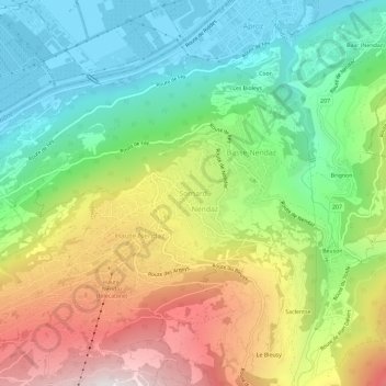
Name: Sornard topographic map, elevation, terrain.
Location: Sornard, Nendaz, Conthey, Wallis, 1997, Switzerland (46.16832 7.28332 46.20832 7.32332)
Average elevation: 1,026 m
Minimum elevation: 473 m
Maximum elevation: 1,888 m
Thank you for supporting this site ❤️
Make a donation
Make a donation
Other topographic maps
Click on a map to view its topography, its elevation and its terrain.