
Make a donation
Ann Arbor topographic map
Click on the map to display elevation.
Make a donation
Ann Arbor
The landscape of Ann Arbor consists of hills and valleys, with the terrain becoming steeper near the Huron River. The elevation ranges from about 750 feet (230 m) along the Huron River to 1,015 feet (309 m) on the city's west side, near the intersection of Maple Road and Pauline Blvd. Ann Arbor Municipal Airport, which is south of the city at 42°13.38′N 83°44.74′W / 42.22300°N 83.74567°W / 42.22300; -83.74567, has an elevation of 839 feet (256 m). Ann Arbor is nicknamed "Tree Town", both due to its name and to the dense forestation of its parks and residential areas. The city contains more than 50,000 trees along its streets and an equal number in parks. Into the early 2000s, the emerald ash borer has destroyed many of the city's approximately 10,500 ash trees.
Make a donation
About this map
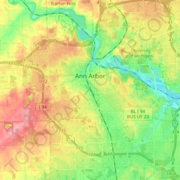
Name: Ann Arbor topographic map, elevation, terrain.
Location: Ann Arbor, Washtenaw County, Michigan, United States (42.22267 -83.79957 42.32389 -83.67581)
Average elevation: 272 m
Minimum elevation: 225 m
Maximum elevation: 328 m
Make a donation
Other topographic maps
Click on a map to view its topography, its elevation and its terrain.
Rawsonville
United States > Michigan > Washtenaw County > Ypsilanti Charter Township
Average elevation: 214 m
Mooreville
United States > Michigan > Washtenaw County > York Charter Township
Average elevation: 222 m
Rawsonville
United States > Michigan > Washtenaw County > Ypsilanti Charter Township
Average elevation: 214 m
Make a donation
Rawsonville
United States > Michigan > Washtenaw County > Ypsilanti Charter Township
Average elevation: 214 m
Frain Lake
United States > Michigan > Washtenaw County > Superior Charter Township
Average elevation: 259 m