
Stroud topographic map
Click on the map to display elevation.
About this map
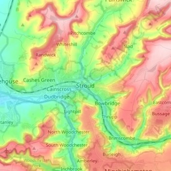
Name: Stroud topographic map, elevation, terrain.
Location: Stroud, Gloucestershire, England, GL5 3BE, United Kingdom (51.70542 -2.25986 51.78542 -2.17986)
Average elevation: 135 m
Minimum elevation: 22 m
Maximum elevation: 265 m
Other topographic maps
Click on a map to view its topography, its elevation and its terrain.
Alderley
United Kingdom > England > Gloucestershire > Stroud
In A Topographical Dictionary of England by Samuel Lewis published in 1831, Alderley is described thus.
Average elevation: 95 m