
Make a donation
Bogota topographic map
Click on the map to display elevation.
Make a donation
About this map
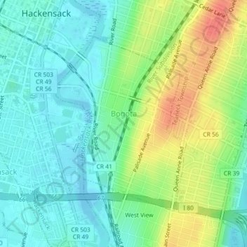
Name: Bogota topographic map, elevation, terrain.
Location: Bogota, Bergen County, New Jersey, United States (40.86557 -74.03979 40.88464 -74.02079)
Average elevation: 19 m
Minimum elevation: -4 m
Maximum elevation: 53 m
Make a donation
Other topographic maps
Click on a map to view its topography, its elevation and its terrain.
Make a donation
River Edge
United States > New Jersey > Bergen County > River Edge > River Edge
Average elevation: 21 m
Make a donation
Make a donation
New Bridge
United States > New Jersey > Bergen County > New Milford > New Bridge
Average elevation: 19 m
Wallington
United States > New Jersey > Bergen County > Wallington > Wallington
Average elevation: 23 m
Warren Point
United States > New Jersey > Bergen County > Fair Lawn > Warren Point
Average elevation: 22 m
Make a donation
Ridgefield
United States > New Jersey > Bergen County > Ridgefield > Ridgefield
Average elevation: 24 m
Make a donation