
Offchurch topographic map
Click on the map to display elevation.
About this map
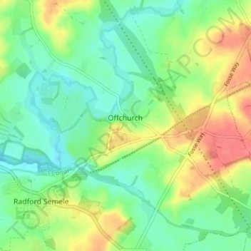
Name: Offchurch topographic map, elevation, terrain.
Location: Offchurch, Warwick, Warwickshire, England, United Kingdom (52.27016 -1.49852 52.30693 -1.43499)
Average elevation: 72 m
Minimum elevation: 50 m
Maximum elevation: 108 m
Other topographic maps
Click on a map to view its topography, its elevation and its terrain.
Rowington Green
United Kingdom > England > Warwickshire > Warwick > Rowington
Average elevation: 114 m
Hampton on the Hill
United Kingdom > England > Warwickshire > Warwick > Hampton on the Hill
Average elevation: 75 m