
Thank you for supporting this site ❤️
Make a donation
Make a donation
Forte Sangallo topographic map
Click on the map to display elevation.
Thank you for supporting this site ❤️
Make a donation
Make a donation
About this map
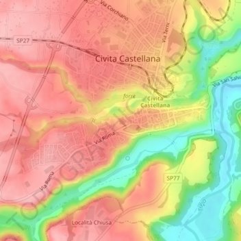
Name: Forte Sangallo topographic map, elevation, terrain.
Average elevation: 131 m
Minimum elevation: 49 m
Maximum elevation: 178 m
Thank you for supporting this site ❤️
Make a donation
Make a donation
Other topographic maps
Click on a map to view its topography, its elevation and its terrain.
Castello di Borghetto
Italia > Lazio > Viterbo > Civita Castellana > Borghetto
Average elevation: 72 m