
Cole County topographic map
Interactive map
Click on the map to display elevation.
About this map
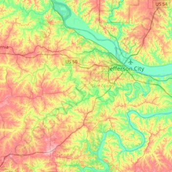
Name: Cole County topographic map, elevation, terrain.
Location: Cole County, Missouri, USA (38.32690 -92.49313 38.74092 -92.00389)
Average elevation: 219 m
Minimum elevation: 156 m
Maximum elevation: 313 m
Other topographic maps
Click on a map to view its topography, its elevation and its terrain.
Springfield
USA > Missouri > Springfield
Springfield, Greene County, Missouri, USA
Average elevation: 389 m
Jefferson City
USA > Missouri > Jefferson City
Jefferson City, Cole County, Missouri, USA
Average elevation: 203 m