
Thank you for supporting this site ❤️
Make a donation
Make a donation
Schanze topographic map
Click on the map to display elevation.
Thank you for supporting this site ❤️
Make a donation
Make a donation
Schanze
Schanze liegt etwas westlich vom Scheitel des Rothaarkamms, dem Hauptkamm des Rothaargebirges, im Naturpark Sauerland-Rothaargebirge. Der Ort befindet sich 6,5 km südöstlich der Schmallenberger Kernstadt und 3,7 km südöstlich des Schmallenberger Ortsteils Grafschaft auf 680 bis 732 m ü. NHN; die Ortsmitte liegt auf 715,9 m Höhe.
Thank you for supporting this site ❤️
Make a donation
Make a donation
About this map
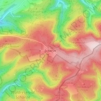
Name: Schanze topographic map, elevation, terrain.
Average elevation: 625 m
Minimum elevation: 445 m
Maximum elevation: 774 m
Thank you for supporting this site ❤️
Make a donation
Make a donation
Other topographic maps
Click on a map to view its topography, its elevation and its terrain.
Esenbeck
Deutschland > Nordrhein-Westfalen > Hochsauerlandkreis > Schmallenberg > Obersorpe
Average elevation: 687 m