
Thank you for supporting this site ❤️
Make a donation
Make a donation
Alt-Georgsmarienhütte topographic map
Click on the map to display elevation.
Thank you for supporting this site ❤️
Make a donation
Make a donation
About this map
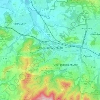
Name: Alt-Georgsmarienhütte topographic map, elevation, terrain.
Average elevation: 127 m
Minimum elevation: 67 m
Maximum elevation: 306 m
Thank you for supporting this site ❤️
Make a donation
Make a donation
Other topographic maps
Click on a map to view its topography, its elevation and its terrain.
Kloster Oesede
Deutschland > Niedersachsen > Landkreis Osnabrück > Georgsmarienhütte > Kloster Oesede
Average elevation: 125 m
Harderberg
Deutschland > Niedersachsen > Landkreis Osnabrück > Georgsmarienhütte > Harderberg
Average elevation: 116 m
Dörenberg
Deutschland > Niedersachsen > Landkreis Osnabrück > Georgsmarienhütte
Average elevation: 200 m
Lammersbrink
Deutschland > Niedersachsen > Landkreis Osnabrück > Georgsmarienhütte
Average elevation: 154 m
Thank you for supporting this site ❤️
Make a donation
Make a donation
Dörenberg
Deutschland > Niedersachsen > Landkreis Osnabrück > Georgsmarienhütte
Average elevation: 200 m