Geolocate

Pasgama topographic map

Interactive map

Click on the map to display elevation.

About this map

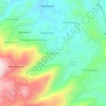
Name: Pasgama topographic map, elevation, terrain.

Location: Pasgama, Kandy District, Central Province, Sri Lanka (7.18569 80.71265 7.22569 80.75265)

Average elevation: 714 m

Minimum elevation: 475 m

Maximum elevation: 1,182 m

Other topographic maps

Click on a map to view its topography, its elevation and its terrain.

Galaha

Sri Lanka > Central Province

Galaha, Kandy District, Central Province, 20420, Sri Lanka

Average elevation: 902 m

Godamunna

Sri Lanka > Central Province

Godamunna, Kandy District, Central Province, 20196, Sri Lanka

Average elevation: 778 m

Bogambara

Sri Lanka > Central Province > Kandy > Bogambara

Bogambara, Kandy, Kandy District, Central Province, 20000, Sri Lanka

Average elevation: 560 m

Lewella Junction

Sri Lanka > Central Province > Kandy > Lewella Junction

Lewella Junction, Kandy, Kandy District, Central Province, 2000, Sri Lanka

Average elevation: 531 m

Central Province

Sri Lanka > Central Province

Central Province, Sri Lanka

Average elevation: 389 m

Glenlyon

Sri Lanka > Central Province > Glenlyon

Glenlyon, Nuwara Eliya District, Central Province, Sri Lanka

Average elevation: 1,464 m

Kandy

Sri Lanka > Central Province > Kandy

Kandy, Kandy District, Central Province, 20000, Sri Lanka

Average elevation: 621 m