
Edmonson County topographic map
Interactive map
Click on the map to display elevation.
About this map
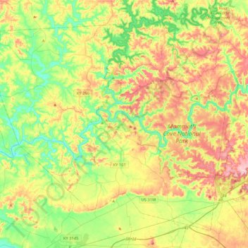
Name: Edmonson County topographic map, elevation, terrain.
Location: Edmonson County, Kentucky, USA (37.05312 -86.46872 37.34086 -86.04896)
Average elevation: 196 m
Minimum elevation: 123 m
Maximum elevation: 300 m
Other topographic maps
Click on a map to view its topography, its elevation and its terrain.
Georgetown
USA > Kentucky > Georgetown
Georgetown, Scott County, Kentucky, 40324, USA
Average elevation: 265 m
Mammoth Cave
USA > Kentucky > Mammoth Cave
Mammoth Cave, Edmonson County, Kentucky, USA
Average elevation: 214 m