
London topographic map
Interactive map
Click on the map to display elevation.
About this map
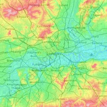
Name: London topographic map, elevation, terrain.
Location: London, Groß-London, England, SW1A 2DX, Vereinigtes Königreich (51.34732 -0.28765 51.66732 0.03235)
Average elevation: 42 m
Minimum elevation: -3 m
Maximum elevation: 163 m
Other topographic maps
Click on a map to view its topography, its elevation and its terrain.
Hounslow
Vereinigtes Königreich > England > London > Hounslow
Hounslow, London, Groß-London, England, TW3 1BL, Vereinigtes Königreich
Average elevation: 21 m
Brent Reservoir
Vereinigtes Königreich > England > London
Brent Reservoir, Dehar Crescent, West Hendon, London Borough of Barnet, London, Groß-London, England, NW9 7BD, Vereinigtes Königreich
Average elevation: 52 m