
Assenois topographic map
Interactive map
Click on the map to display elevation.
About this map
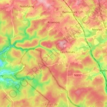
Name: Assenois topographic map, elevation, terrain.
Location: Assenois, Léglise, Neufchâteau, Luxembourg, Wallonie, Belgique (49.74012 5.41165 49.81950 5.52715)
Average elevation: 420 m
Minimum elevation: 353 m
Maximum elevation: 476 m
Other topographic maps
Click on a map to view its topography, its elevation and its terrain.
Bombois
Belgique > Luxembourg > Neufchâteau > Léglise
Bombois, Ebly, Léglise, Neufchâteau, Luxembourg, Wallonie, 6642, Belgique
Average elevation: 472 m
Anlier
Belgique > Luxembourg > Neufchâteau > Léglise
Anlier, Léglise, Neufchâteau, Luxembourg, Wallonie, Belgique
Average elevation: 459 m
Witry
Belgique > Luxembourg > Neufchâteau > Léglise
Witry, Léglise, Neufchâteau, Luxembourg, Wallonie, Belgique
Average elevation: 457 m