
Thank you for supporting this site ❤️
Make a donation
Make a donation
Alvaiázere topographic map
Click on the map to display elevation.
Thank you for supporting this site ❤️
Make a donation
Make a donation
About this map
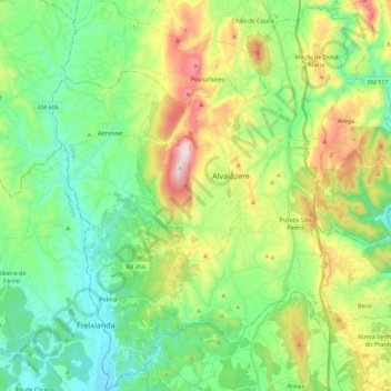
Name: Alvaiázere topographic map, elevation, terrain.
Location: Alvaiázere, Leiria, Portugal (39.73089 -8.48397 39.90120 -8.30105)
Average elevation: 258 m
Minimum elevation: 93 m
Maximum elevation: 615 m
Thank you for supporting this site ❤️
Make a donation
Make a donation
Other topographic maps
Click on a map to view its topography, its elevation and its terrain.