
Thank you for supporting this site ❤️
Make a donation
Make a donation
Crater Hill topographic map
Click on the map to display elevation.
Thank you for supporting this site ❤️
Make a donation
Make a donation
About this map
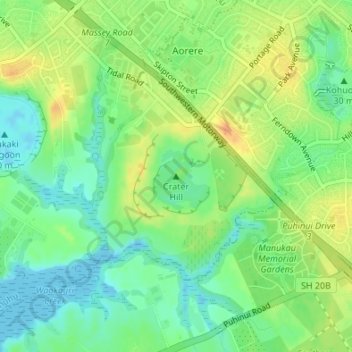
Name: Crater Hill topographic map, elevation, terrain.
Location: Crater Hill, Māngere-Ōtāhuhu, Auckland, 2024, New Zealand (-36.98612 174.82668 -36.98602 174.82678)
Average elevation: 17 m
Minimum elevation: -2 m
Maximum elevation: 38 m
Thank you for supporting this site ❤️
Make a donation
Make a donation
Other topographic maps
Click on a map to view its topography, its elevation and its terrain.