
Thank you for supporting this site ❤️
Make a donation
Make a donation
Vabres topographic map
Click on the map to display elevation.
Thank you for supporting this site ❤️
Make a donation
Make a donation
About this map
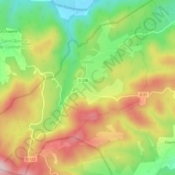
Name: Vabres topographic map, elevation, terrain.
Average elevation: 349 m
Minimum elevation: 205 m
Maximum elevation: 501 m
Thank you for supporting this site ❤️
Make a donation
Make a donation
Other topographic maps
Click on a map to view its topography, its elevation and its terrain.
Pont de la Glacière et Pied de Fée
Frankrijk > Occitanië > Gard > Durfort-et-Saint-Martin-de-Sossenac
Average elevation: 174 m
Thank you for supporting this site ❤️
Make a donation
Make a donation