
Town of La Grange topographic map
Interactive map
Click on the map to display elevation.
About this map
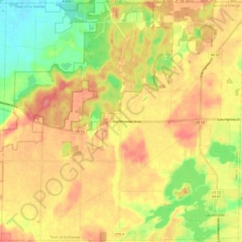
Name: Town of La Grange topographic map, elevation, terrain.
Location: Town of La Grange, Walworth County, Wisconsin, United States (42.75589 -88.66177 42.84300 -88.54154)
Average elevation: 285 m
Minimum elevation: 243 m
Maximum elevation: 316 m
Other topographic maps
Click on a map to view its topography, its elevation and its terrain.
Walworth
United States > Wisconsin > Walworth County
Walworth, Walworth County, Wisconsin, 53184, United States
Average elevation: 304 m
Delavan Lake
United States > Wisconsin > Walworth County
Delavan Lake, Town of Delavan, Walworth County, Wisconsin, United States
Average elevation: 294 m
Darien
United States > Wisconsin > Walworth County
Darien, Walworth County, Wisconsin, 53114, United States
Average elevation: 287 m
Abells Corners
United States > Wisconsin > Walworth County
Abells Corners, Town of Lafayette, Walworth County, Wisconsin, 53121, United States
Average elevation: 275 m
Millard
United States > Wisconsin > Walworth County
Millard, Town of Sugar Creek, Walworth County, Wisconsin, United States
Average elevation: 283 m
Tibbets
United States > Wisconsin > Walworth County
Tibbets, Town of Sugar Creek, Walworth County, Wisconsin, 53121, United States
Average elevation: 282 m
Troy Center
United States > Wisconsin > Walworth County
Troy Center, Town of Troy, Walworth County, Wisconsin, United States
Average elevation: 269 m
Como
United States > Wisconsin > Walworth County
Como, Town of Geneva, Walworth County, Wisconsin, United States
Average elevation: 289 m
Town of Lyons
United States > Wisconsin > Walworth County
Town of Lyons, Walworth County, Wisconsin, United States
Average elevation: 261 m
Potter Lake
United States > Wisconsin > Walworth County
Potter Lake, Town of East Troy, Walworth County, Wisconsin, United States
Average elevation: 258 m
Whitewater
United States > Wisconsin > Walworth County
Whitewater, Walworth County, Wisconsin, 53501, United States
Average elevation: 254 m
East Troy
United States > Wisconsin > Walworth County
East Troy, Walworth County, Wisconsin, 53120, United States
Average elevation: 264 m
Pell Lake
United States > Wisconsin > Walworth County > Village of Bloomfield
Pell Lake, Village of Bloomfield, Walworth County, Wisconsin, 53157, United States
Average elevation: 263 m
Geneva Lake
United States > Wisconsin > Walworth County > Lake Geneva
Geneva Lake, Lake Geneva, Town of Linn, Walworth County, Wisconsin, 53125, United States
Average elevation: 288 m
Williams Bay
United States > Wisconsin > Walworth County
Williams Bay, Walworth County, Wisconsin, 53191, United States
Average elevation: 287 m
Town of Geneva
United States > Wisconsin > Walworth County
Town of Geneva, Walworth County, Wisconsin, 53147, United States
Average elevation: 296 m
Town of Richmond
United States > Wisconsin > Walworth County
Town of Richmond, Walworth County, Wisconsin, United States
Average elevation: 293 m
Lake Como
United States > Wisconsin > Walworth County > Lake Como
Lake Como, Town of Geneva, Walworth County, Wisconsin, 53191, United States
Average elevation: 283 m
Little Prairie
United States > Wisconsin > Walworth County > Little Prairie
Little Prairie, Town of Troy, Walworth County, Wisconsin, United States
Average elevation: 290 m
Como Lake
United States > Wisconsin > Walworth County > Como
Como Lake, Como, Town of Geneva, Walworth County, Wisconsin, United States
Average elevation: 289 m
Town of Sugar Creek
United States > Wisconsin > Walworth County
Town of Sugar Creek, Walworth County, Wisconsin, 53121, United States
Average elevation: 289 m
Lake Geneva
United States > Wisconsin > Walworth County
Lake Geneva, Walworth County, Wisconsin, United States
Average elevation: 275 m
Elkhorn
United States > Wisconsin > Walworth County
Elkhorn, Walworth County, Wisconsin, 53121, United States
Average elevation: 299 m
Delavan
United States > Wisconsin > Walworth County
Delavan, Walworth County, Wisconsin, 53115, United States
Average elevation: 287 m
Big Foot Beach State Park
United States > Wisconsin > Walworth County > Lake Geneva
Big Foot Beach State Park, Lake Geneva, Walworth County, Wisconsin, United States
Average elevation: 276 m