
Thank you for supporting this site ❤️
Make a donation
Make a donation
Rocky Creek topographic map
Click on the map to display elevation.
Thank you for supporting this site ❤️
Make a donation
Make a donation
About this map
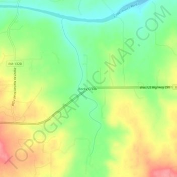
Name: Rocky Creek topographic map, elevation, terrain.
Location: Rocky Creek, Blanco County, Texas, United States (30.23353 -98.54697 30.27353 -98.50697)
Average elevation: 428 m
Minimum elevation: 387 m
Maximum elevation: 477 m
Thank you for supporting this site ❤️
Make a donation
Make a donation
Other topographic maps
Click on a map to view its topography, its elevation and its terrain.