
A Barrela topographic map
Interactive map
Click on the map to display elevation.
About this map
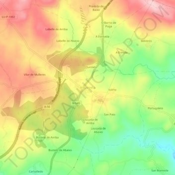
Name: A Barrela topographic map, elevation, terrain.
Location: A Barrela, Carballedo, Chantada, Lugo, Galicia, 27520, España (42.51976 -7.83302 42.55976 -7.79302)
Average elevation: 627 m
Minimum elevation: 517 m
Maximum elevation: 727 m
Other topographic maps
Click on a map to view its topography, its elevation and its terrain.
Penasillás
Penasillás, A Laxe, Chantada, Lugo, Galicia, 27512, España
Average elevation: 692 m
Pesqueiras
Pesqueiras, Chantada, Lugo, Galicia, España
Average elevation: 488 m
Taboada dos Freires
Taboada dos Freires, Taboada, Chantada, Lugo, Galicia, España
Average elevation: 627 m