
Forked River topographic map
Interactive map
Click on the map to display elevation.
About this map
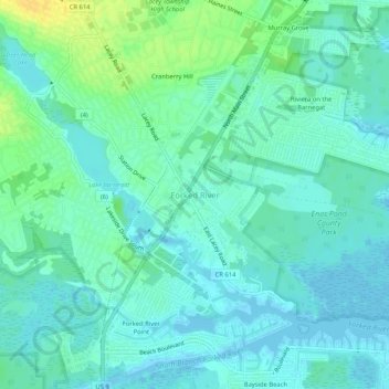
Name: Forked River topographic map, elevation, terrain.
Average elevation: 7 m
Minimum elevation: -3 m
Maximum elevation: 23 m
Other topographic maps
Click on a map to view its topography, its elevation and its terrain.
Lanoka Harbor
United States > New Jersey > Ocean County > Lacey Township
Lanoka Harbor, Lacey Township, Ocean County, New Jersey, 08734, United States
Average elevation: 7 m
Cranberry Hill
United States > New Jersey > Ocean County > Lacey Township > Forked River
Cranberry Hill, Forked River, Lacey Township, Ocean County, New Jersey, 08731, United States
Average elevation: 10 m
Forked River Beach
United States > New Jersey > Ocean County > Lacey Township
Forked River Beach, Lacey Township, Ocean County, New Jersey, 08731, United States
Average elevation: 2 m
Lacey Township
United States > New Jersey > Ocean County > Lacey Township
Lacey Township, Ocean County, New Jersey, United States
Average elevation: 26 m
Bayside Beach
United States > New Jersey > Ocean County > Lacey Township
Bayside Beach, Lacey Township, Ocean County, New Jersey, 08731, United States
Average elevation: 3 m