
Thank you for supporting this site ❤️
Make a donation
Make a donation
Perl topographic map
Click on the map to display elevation.
Thank you for supporting this site ❤️
Make a donation
Make a donation
Perl
Der höchste Punkt der Gemeinde ist der unmittelbar an der französischen Grenze gelegene Schneeberg in Eft mit einer Höhe von 429 m ü. NHN.
Thank you for supporting this site ❤️
Make a donation
Make a donation
About this map
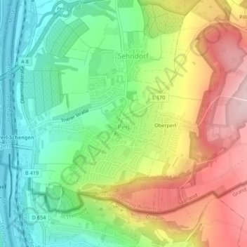
Name: Perl topographic map, elevation, terrain.
Location: Perl, Landkreis Merzig-Wadern, Saarland, Deutschland (49.46415 6.36835 49.48373 6.39522)
Average elevation: 248 m
Minimum elevation: 138 m
Maximum elevation: 396 m
Thank you for supporting this site ❤️
Make a donation
Make a donation
Other topographic maps
Click on a map to view its topography, its elevation and its terrain.