
Meymac topographic map
Interactive map
Click on the map to display elevation.
About this map
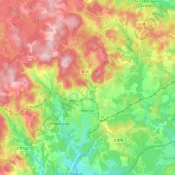
Name: Meymac topographic map, elevation, terrain.
Average elevation: 763 m
Minimum elevation: 584 m
Maximum elevation: 981 m
Other topographic maps
Click on a map to view its topography, its elevation and its terrain.
Lontrade
Frankrijk > Nieuw-Aquitanië > Corrèze > Meymac
Lontrade, Meymac, Ussel, Corrèze, Nieuw-Aquitanië, Metropolitaans Frankrijk, 19250, Frankrijk
Average elevation: 873 m