
Thank you for supporting this site ❤️
Make a donation
Make a donation
Behler See topographic map
Click on the map to display elevation.
Thank you for supporting this site ❤️
Make a donation
Make a donation
About this map
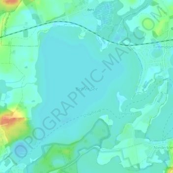
Name: Behler See topographic map, elevation, terrain.
Average elevation: 27 m
Minimum elevation: 19 m
Maximum elevation: 63 m
Thank you for supporting this site ❤️
Make a donation
Make a donation
Other topographic maps
Click on a map to view its topography, its elevation and its terrain.
Großer Plöner See
Deutschland > Schleswig-Holstein > Plön > Plön
Mit 28 km² Seefläche und einer Tiefe von bis zu 56 m ist der vollständig im Naturpark Holsteinische Schweiz liegende See der größte und tiefste in Schleswig-Holstein. Am Nordufer liegt die Kreisstadt Plön, mit dem Wahrzeichen des Sees, dem auf einer Anhöhe gelegenen Plöner Schloss. Weitere Orte am Ufer…
Average elevation: 32 m