
Thank you for supporting this site ❤️
Make a donation
Make a donation
Rauher Jakob topographic map
Click on the map to display elevation.
Thank you for supporting this site ❤️
Make a donation
Make a donation
Rauher Jakob
Seine Kuppe liegt im Unterharz innerhalb des Naturparks Harz/Sachsen-Anhalt. Sie befindet sich rund 2,7 km südsüdöstlich von Elend und etwa 3 km (je Luftlinie) nordnordwestlich von Tanne. Ein etwa 1.000 m nordöstlich vom Hauptgipfel gelegener Nebengipfel des Rauhen Jakobs ist die Ramsenhöhe (550,2 m ü. NN).
Thank you for supporting this site ❤️
Make a donation
Make a donation
About this map
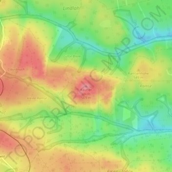
Name: Rauher Jakob topographic map, elevation, terrain.
Average elevation: 526 m
Minimum elevation: 479 m
Maximum elevation: 570 m
Thank you for supporting this site ❤️
Make a donation
Make a donation
Other topographic maps
Click on a map to view its topography, its elevation and its terrain.