
Peace River topographic map
Interactive map
Click on the map to display elevation.
About this map
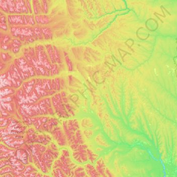
Name: Peace River topographic map, elevation, terrain.
Location: Peace River, British Columbia, Canada (56.26232 -123.26728 57.54232 -121.98728)
Average elevation: 1,118 m
Minimum elevation: 499 m
Maximum elevation: 2,399 m
Other topographic maps
Click on a map to view its topography, its elevation and its terrain.
Vancouver Island
The rain shadow effect of the island's mountains, as well as the mountains of Washington's Olympic Peninsula, creates wide variation in precipitation. The west coast is considerably wetter than the east coast. Average annual precipitation ranges from 6,650 mm (262 in) at Hucuktlis Lake on the west coast…
Average elevation: 411 m
Area C (Hagensborg/Talchako/Atnarko)
Canada > British Columbia > Central Coast Regional District
Average elevation: 1,432 m
Area G (Upper Similkameen/Hedley)
Canada > British Columbia > Regional District of Okanagan-Similkameen
Average elevation: 1,305 m
Victoria
Canada > British Columbia > Capital Regional District
Victoria, British Columbia, is situated on the southern tip of Vancouver Island, Canada, and boasts a diverse and varied topography. The city is characterized by rolling hills, rugged coastal cliffs, and lush valleys, providing a striking contrast between mountainous terrain and flatland areas. To the north…
Average elevation: 17 m